Recently the ice2ice article Risebrobakken, Bjørg, and Sarah Miche Patricia Berben. “Early Holocene establishment of the Barents Sea Arctic front.” Frontiers in Earth Science 6 (2018): 166 was published in Frontiers Earth Science. You can find the full article here. Below a short summary by the two ice2ice authors Bjørg Risebrobakken and Sarah M. P. Berben from Uni Research Climate, Bjerknes Centre for Climate Research, Bergen, Norway and Department of Earth Science, University of Bergen, Bjerknes Centre for Climate Research, Bergen, Norway, respectively.
by Bjørg Risebrobakken and Sarah M. P. Berben
A main feature of the Barents Sea oceanography is the Arctic front. The Arctic front marks the transition between the dominating water masses of the Barents Sea: Atlantic Water in the south and Arctic Water in the north. Presently, the Barents Sea Arctic front is directed by the topography of the Bear Island Trough and to some degree the location of the sea ice boundary.
During the last glacial maximum, the Svalbard-Barents Sea and Scandinavian Ice Sheets covered the Barents Sea. Hence, no water entered the Barents Sea, neither from the south nor from the north. Following the deglaciation of the Barents Sea, the present-day ocean circulation developed. The evolution of how the present location of the Barents Sea Arctic front established during the early Holocene is documented by foraminiferal relative assemblage data from six core sites along the western Barents Sea margin and opening. The relative abundance of Arctic front indicator Turborotalita quinqueloba, in combination with the cold, polar Neogloboquadrina pachyderma and warm, Atlantic Neogloboquadrina incompta, are used to infer the location of the Barents Sea Arctic front relative to the individual core sites.
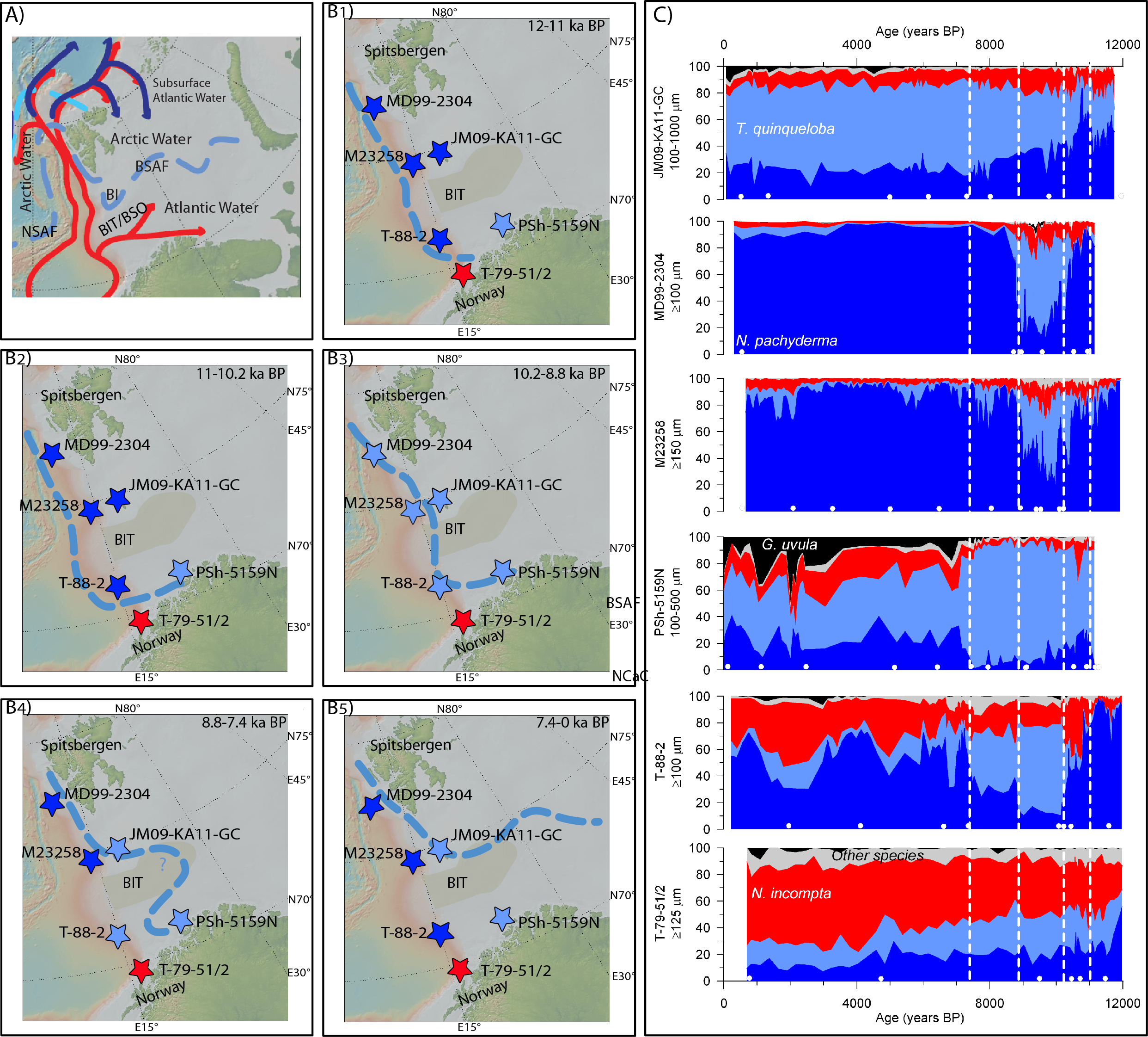
Until ca. 11 ka BP, the Barents Sea Arctic front followed the western margin of the Barents Sea. All sites along the Barents Sea margin where still dominated by Arctic Water between ca. 11 and 10.2 ka BP, however, the Barents Sea Arctic front turned eastwards into the southwestern Barents Sea.
From ca. 10.2 to 8.8 ka BP, the Barents Sea Arctic front moved eastward and was located right above most sites as it followed the Barents Sea margin. The northwestern Barents Sea Arctic front was close to the present location from ca. 8.8 to 7.4 ka BP, however, it was still confined to the southwestern Barents Sea.
From ca. 7.4 ka BP, the Barents Sea Arctic front has been located close to the present position, along the margin southwards from Svalbard, turning eastwards along and beyond the northern Bear Island Trough margin.